Sunday, March 29, 2009

Spring Bob (March 28, 2009)

-----
Uh, yes...I did realize
it's a double entendre...
----
-----
Can't have shaggy hair
for softball season!
----

Saturday, March 28, 2009

First Sunday of Spring 2009

-----
March 22, 2009
-----
Today I traveled to a couple
of city parks. The sun was out
part of the afternoon, which
made springtime feel real.
-----
The first stop was a waterfall
I'd only recently read about.
I've been all over northeastern
Ohio observing these natural
wonders but did not know
Columbus had one of its own!
-----
-----
Just west of the intersection of
Riverside Drive and Hayden Run
(also Bethel Road just a few
hundred feet to the east) lies
the Griggs Nature Preserve
and home of Hayden Falls.
-----
-----
As you can see above, Hayden
Run (the creek's name) empties
into the Scioto River and what is
known as the Griggs Reservoir.
-----
-----
I honestly didn't know Columbus
had any rock formations
whatsoever! This was a
fantastic little valley!
-----
-----
I personally think this spot is
a bit of a wasted treasure.
Because of the four-laned
street on its northern side
and enormous homes to
the south, there is really
no way to make this into
the natural area it should be.
-----
-----
Certainly not as clear as
Clear Fork was yesterday.
it's still an adorable stream.
-----

-----
Ah...the waterfall!
-----
-----
At 25 feet, it's a pretty
impressive cascade
for the middle of
Columbus, OH!
-----


-----
You know me...always on the
lookout for signs of spring!
-----
-----
This view is from an overlook
off Hayden Run Road.
-----
-----
Even the streambed is impressive!
-----
-----
Here's a little video I shot
while I was at the bottom
of the gorge. Enjoy!
-----

-----
You might also enjoy this
little website:
-----
The second spot I sought
on my trip today was
Highbanks Metro Park.
-----
-----
Highbanks is located just
north of Interstate 270 west
of Highway 23 in Delaware
County. (I live just west of
23 myself but 14.5 miles
south of the park entrance.)
-----
Here is a map of the
park's trails:
I only meandered the
western and southern trails.
-----
-----
While the Scioto River is
"in my backyard," at this
location the state scenic
river Olentangy makes
its journey south.
-----


-----
Okay, so I'm an architect-
lover, too! I thought this
little bridge was so cute!
-----
-----
Below is the park's nature center.
-----
-----
Although this kind of landscape
is prevalent in Northern MS,
it's not too common in
Central OH.
-----
-----
Adena Mound is a tiny
Native American burial ground.
-----
-----
At first I was totally impressed
with this little graveyard.
How did it get here? Especially
when the father, who died
the latest, was also on site!?!
-----
-----
Upon reading the placard,
I realized the tombstones
were moved here at a later
date. Do notice the footstones
in the above shot though:
ponder how tiny the
smallest child was when
he died...
-----
-----
Sally, the wife, died at
age 35 in 1818.
Her husband Joseph died
two years later at age 53!
----------
What I found interesting was
the fact that the couple's
six-year-old son Ebenezer
died just shortly before his father.
-----

-----
I had to snap this placard
to remind me how LOUD
the woodpecker was at
the top of one of the
highest trees!
-----
-----
It's hard to read this sign, but
it tells of an hill created by
Native Americans as a kind of
property boundary to their
village. It was excavated by
archaeologists in the early
1900s and found to contain
two type of clay that are not
part of the soils of this area.
-----


-----
Why is Highbanks called
Highbanks? Well, because
of these high banks, of course!
-----
-----
The Olentangy River wanders
southward below.
-----
-----
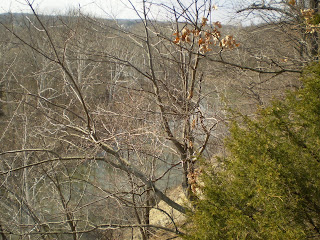
This final shot shows
manmade structures
in the distance.
-----
-----
Time to go home and rest!
Even at a leisurely pace,
four miles of hiking today
after three yesterday is
a bit much!
-----

Monday, March 23, 2009

eMANuel (March 15, 2009)

-----
King Avenue's Men's Quartet
and their hunky accompaniest!
-----
-----
Top: me; Dan Bidelspach (baritone)
Bottom: Jason Krauss (second tenor/lead);
Keith Yokum (first tenor);
and John Alfano (bass)

First Saturday of Spring 2009

-----
My friend Tim Denis of Mansfield
and I decided to go hiking at
Mohican State Park on March 21, 2009.
-----
The photo below shows the Clear
Fork of the Mohican River on its
sojourn through the village of
Bellville. We would follow this
stream throughout our day trip.
----
-----
Flowing east to the Mohican
River then on to the Walhonding
and Muskinghum rivers, this little
stream will eventually wind up
in the Gulf of Mexico by way
of the Ohio and Mississippi rivers.
-----
-----
Our first stop was this little chapel
called the Memorial Shrine.
It is a place for remembering
the war dead
-----

-----
Our next stop was inside the
park. Unlike driving next to
the stream in Bellville, the
Clear Fork was in the beautifully
eroded valley below us here.
-----

-----
I love the Eastern Hemlock that
line the upper portions of the
hills in this area of the state.
-----


-----
Ten to twelve buzzards soared
majestically overhead as we
surveyed the scenery.
-----
-----
We decided to head toward
the covered bridge next.
-----
-----
The island above was a
pastoral masterpiece.
-----
Below, I wanted to think that
the stones in the river were
put there by God, but Tim
thinks they were placed there
by man to help guide canoes
into the deeper part of the stream.
-----

-----
Tim was able to capture the
U-shaped stone diversion, the
covered bridge and my ugly mug
all in a single shot.
(It was overcast, but it doesn't
take much to get these blue
eyes to squint!)
-----


-----
I know...I take weird photos.
Why this swampy looking bit
of ground with some weeds, huh?
.....It was the only sign of spring.
-----
-----
Trust me: it was much too cool
for someone to be wearing
flip-flops at the park!
Tim thinks it's a murder clue.
-----
-----
Do you see the archer/fisherman
in the photo below?
-----
-----
We were heading toward Big and
Little Lyons waterfalls.
I joked when we saw this tiny
tumble of water that this must
be Little Lyons Falls.
Truth is that this is the same
water that created BIG
Lyons Falls! Go figure!
-----
-----
I realize now I should have had
people in the photo to give
some perspective of Big Lyons
Falls in the shot below.
-----
-----
From the top of the waterfall
to the base is 40 feet!
-----
-----
And, yes, you will notice as you
peruse these photos my greatest
fascination -- ice!
-----
-----
I suppose the water comes off the
ledge in such a small quantity
but at such a great height that
the mist created by the splashing
causes the cold rocks to become
ice-encased. Fantastic!
-----
-----
Oh, it was chilly the day we
hiked...but it was in the 40s--
not nearly cold enough for
frozen ground!
-----
-----
I loved this huge piece of ice
in the shot below. I can just
imagine what it must have sounded
like when the winter thaw
released it from its ledge-
clutching height and allowed
it to plunge to the cave floor!
-----


----
We climbed to the top of the hill
so we could see what was making
all the fuss below.
It was this tiny channel of water,
barely one- to two-feet wide.
-----
-----
Here the water makes its
suicidal plunge!
-----
------
Finally! A photo that gives
some perspective!
-----
-----
And another that shows
NO perspective at all!
------
-----
I try to find things in nature
that others might miss.
I really found this black mass
on the birch tree (one of several)
to be cool. While I was sure
once I got close enough
that the growth was some
form of fungus, it wasn't until
I got home and saw this photo
that I realized the sparkling
quality of the parasite.
------
-----
After a heavy wind storm last
year, an uprooted tree isn't that
uncommon. What I found
fascinating was the rocks that
made up a portion of its root
mass. It must have been like
trying to wrench the tree
from concrete when Mother
Nature let loose!
-----
-----
Ah...Little Lyons Falls...
-----
-----
This one is much less accessible
than its older sister.
-----
-----
Strangely, I found this
waterfall much more
mesmerizing than the
bigger one. I think it had
to do with the difficulty
I had getting to its base.
-----
We were blowing cold smoke
with every breath in this portion
of the hike.
-----
-----
Again, an enormous ice chuck
on a slow thaw from the winter
freeze. Notice the Northern
red oak leaves--about six inches
long--embedded in the ice.
-----
-----
I wish I had a better shot of this
icicle. It was probably twenty feet
long. Actually, it was a root
sticking out from the side of the hill
that had slowly grown an ice
coat from the trickle of water
that ran down its long leg.
-----


Here is the small water source
that created the lovely falls.
-----
-----
I'm not sure how the log fell
into this position.
-----
-----
The water is little more than
handwidth before it tumbles
over the ledge.
-----
-----
From this side, we had a better
view...both of the waterfall and
the sign saying that getting
close to the waterfall was
prohibited. Whoops!
-----
-----
At the end of the rugged
trail, it seemed the fork
started from a great
underground spring beneath
this tall hill.
-----
----
Actually, the Army Corp of
Engineers created this manmade
dam in the early 1900s.
-----
This is Pleasant Hill Lake, formed from the
stream, on the other side of the dam.
-----
And, strangely, this is the dam.
------
-----
This stone structure above allows
the water to flow underneath the
dam and release the water on
the other side of the road.
-----
-----
The "octogonal" looking contraption
below is a flood control device.
It has never been used!
-----

-----
This is another shot of the flood
control device. Should a deluge
of catastophic proportions ever
occur, the water would run into
this drain to keep the land around
the lake from going under water.
-----
-----
This is a shot of the dam
from above. The water flows into
the base of the dam like a
gigantic kitchen drain.
-----

-----
This guy is fishing at the spillway.
(What I want to know is how he
got there!)
-----
-----
The rerouted Clear Fork of the
Mochican River!
-----


-----
Thanks, Tim, for spending
the day with me!
-----